Geoinformatics
Research and education are conducted on methodologies to acquire, process, and utilize spatial information for disaster prevention and environmental protection. In particular, we focus on satellite remote sensing, 3-D digital photogrammetry, laser surveying, and geographic information systems for monitoring, modeling, planning, and management of the national land and the environment.
Academic Staff
Junichi SUSAKI
Professor (Graduate School of Engineering)
Research Topics
Sensors used in satellite remote sensing are classified into microwave sensors including Synthetic Aperture Radar (SAR) and optical sensors in the visible to thermal infrared bands. I'm interested in developing methodology to combine these different types of sensor data with respect to the advantages for the applications such as disaster mitigation and environmental change analysis.
Contacts
Room 205, Bldg. C1, Katsura Campus
TEL&FAX: +81-75-383-3300
E-mail: susaki.junichi.3r kyoto-u.ac.jp
Yoshie ISHII
 Assistant Professor (Graduate School of Engineering)
Research Topics
Contacts
Room 204, Bldg. C1, Katsura Campus
TEL: +81-75-383-3301
E-mail: ishii.yoshie.4k![]() kyoto-u.ac.jp
kyoto-u.ac.jp
Research Topics
Assessment of disaster damage and environmental changes by remote sensing
Satellite or airborne sensors can regularly observe temporal changes of the national land and the environment at global or regional scale. In this project, we are developing methodologies for observing the current state and changes of the Earth's surface using optical and radar sensors for disaster prevention and environmental protection.

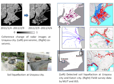
Fig1. Detection of liquefaction areas in Kanto region caused by the 2011 East Japan Earthquake. Liquefaction areas were detected using ALOS-PALSAR radar interferometry.

Fig.2 Tracking changes of mangrove forests in Vietnam from 1990 to 2010. Multiple Landsat optical images were used
Estimation of Urban Density Using Polarimetric SAR (PolSAR) data
We are conducting researches about estimating building density using satellite-borne polarimetric synthetic aperture radar (PolSAR). In general, we need at least two images to estimate three-dimensional (3D) data and the related data, but the developed method can estimate it only from one PolSAR image by extracting the data related to structural distribution. The method is potential to be applied for mapping urban areas where statistics are insufficient for comparing the urban structures.

Fig.3 Urban density estimated using satellite images and generated using GIS data: (Left) Urban density estimated using ALOS/PALSAR launched by JAXA, Japan, (middle) building-to-land ratio and (right) floor-to-land ratio generated using Zmap TownII, ZENRIN. The estimated urban density has a high correlation with building-to-land ratio
3D building modeling using airborne LiDAR and aerial images
We are developing knowledge-based algorithms for automatically generating three-dimensional (3D) building models in dense urban areas by using airborne light detection and ranging (LiDAR) data and aerial images. Automatic 3D building modeling using LiDAR is challenging in dense urban areas, in which houses are typically located close to each other and their heights are similar. This makes it difficult to separate point clouds into individual buildings. It was found that a combination of airborne LiDAR and aerial images can be an effective approach to resolve this issue.

Fig.4 Example of 3D building modeling in Higashiyama-Ward, Kyoto:(Upper left) Aerial image, (upper right) segmentation results, and (lower) modeling results for an area containing low-rise buildings. In the models, red denotes a flat-roof building, blue denotes a gable-roof building, green denotes a hip-roof building, pink denotes a slant-roof building, black denotes a flat big building and yellow denotes a flat model generated using finally unused points.
